High-resolution, in-situ P-wave and S-wave velocity measurement between boreholes. The most direct way to characterise the stiffness and seismic site class of a specific stratum at depth — for dam foundations, large structures, and ground-motion modelling across East Africa.
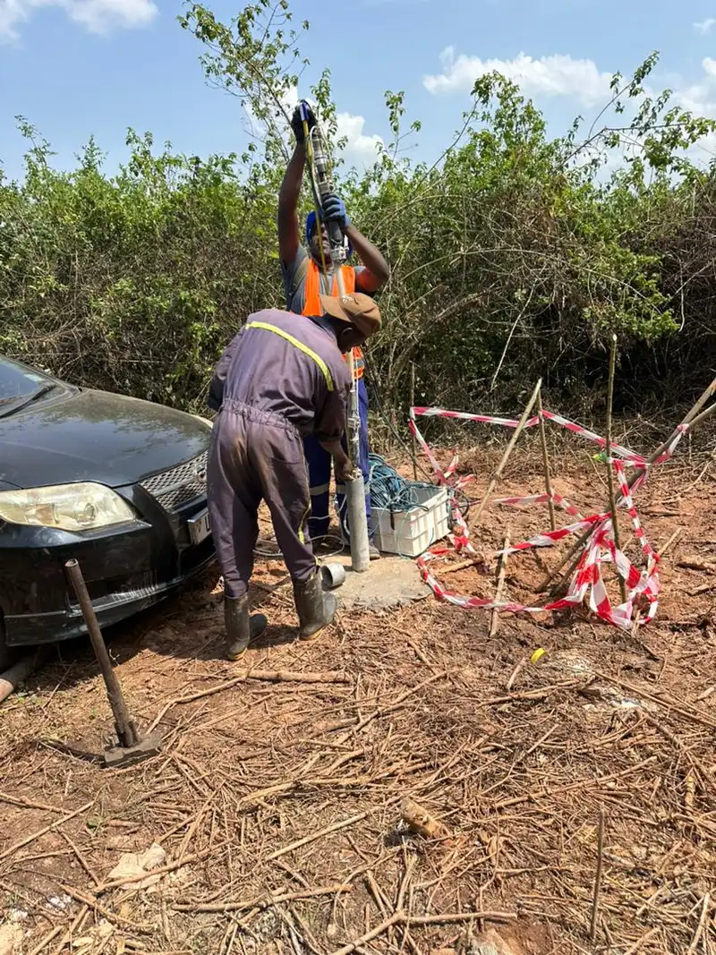
A crosshole seismic survey is a borehole geophysical method that measures the velocity of seismic waves directly between two or more boreholes. A seismic source is fired at a series of depths in one borehole while an array of geophones or hydrophones in an adjacent borehole records the arriving compressional (P) and shear (S) waves. Because the wavepath travels horizontally through the ground between the boreholes, the measurement is largely independent of the low-velocity surface layer that complicates surface and downhole surveys.
This direct, depth-controlled geometry makes a crosshole seismic survey in Uganda the highest-resolution way to determine in-situ shear-wave velocity and stiffness at the exact elevation that matters for your foundation or embankment. The results feed straight into seismic site classification, low-strain modulus estimation, and ground-response (site amplification) models used by structural and geotechnical engineers.
Georesolve Africa operates crosshole seismic surveys across Uganda, Rwanda, Burundi, and the wider East African region, typically as part of an integrated downhole–crosshole investigation for dams, power stations, bridges, and other critical infrastructure where confidence in subsurface stiffness is essential.
Georesolve operates a multi-channel seismic system configured for crosshole and downhole investigations, using borehole-cased access to measure seismic velocities at depth.
| Component | Specification |
|---|---|
| Seismograph | Multi-channel digital engineering seismograph with GPS timing for accurate first-arrival picking |
| Borehole source | Impact / piezoelectric borehole source generating repeatable P and S waves, deployable at depth |
| Receiver chain | Geophone or hydrophone string (typically 3–12 levels) locked at depth in the receiver borehole |
| Boreholes | Two or more PVC-cased or open boreholes, generally 3–10 m apart, drilled to target depth |
| Positioning | Depth-encoded source and receiver probes with cable reel and controller for precise levelling |
| Measured parameters | Compressional (Vp) and shear (Vs) wave velocities, travel times, S-wave first arrivals |
| Derived products | Shear modulus, Poisson's ratio, low-strain stiffness, seismic site class (Vs30) |
For surface-based shear-wave profiling over wider areas, Georesolve also operates Multichannel Analysis of Surface Waves (MASW) and downhole seismic surveys, which are complementary to the crosshole method.
Direct stiffness and site-class verification of foundation strata and embankment zones between boreholes for dam safety and design.
High-confidence Vs30 and site-class determination for structures in seismic or volcanic-risk zones across East Africa.
In-situ shear modulus and Poisson's ratio for foundation, pile, and embankment modelling where lab samples over-estimate stiffness.
Tomographic imaging of voids, weak seams, and fracture zones along the borehole-to-borehole plane.
Depth-specific velocity profiles for site amplification and ground-response analyses supporting structural design.
Acceptance testing of compacted fill, grouted zones, and treated ground between adjacent boreholes.
Every crosshole seismic survey is delivered as a complete, interpretation-ready data package:
Georesolve carried out an integrated downhole and crosshole seismic investigation for the pre-feasibility engineering studies and site assessment of the proposed Kampala Livestock Feeds Mill plant. The programme delivered in-situ borehole seismic velocity profiling for dynamic soil property determination and seismic site classification.
The crosshole component provided direct, depth-controlled measurement of P-wave and S-wave velocities between boreholes, resolving the shear modulus of the foundation strata with far greater confidence than surface methods alone. The resulting site class and low-strain modulus fed directly into the foundation design of the large-scale industrial processing infrastructure.

A crosshole seismic survey measures the velocity of seismic waves between two or more boreholes. A seismic source is fired in one borehole at several depths while geophones or hydrophones in an adjacent borehole record the arriving P and S waves. Because the wavepath travels horizontally through the ground between the boreholes, the measurement is nearly independent of shallow weathering and gives a high-resolution image of the velocity structure at depth.
In downhole seismic the source is at the surface and receivers are lowered down a single borehole, so the wave travels diagonally from surface to depth. In crosshole seismic both source and receivers are in boreholes, so the wave travels horizontally between them. Crosshole gives a more direct, higher-resolution measure of the in-situ velocity between the boreholes and is less affected by the low-velocity surface layer. The two methods are complementary and are often run together.
A crosshole survey measures compressional (P-wave) and shear (S-wave) velocities in situ between boreholes. From these we derive the shear modulus, Poisson's ratio, low-strain stiffness, and seismic site class. Crosshole tomography can also image anomalous zones (voids, weak layers, fracture zones) along the borehole-to-borehole plane.
Crosshole seismic is ideal when you need high-confidence, depth-specific velocity data between two boreholes — for example, dam foundation acceptance testing, characterisation of a specific stratigraphic interval, detection of cavities or weak seams, or verification of the stiffness used in a foundation or embankment model. It is most valuable where surface seismic methods cannot resolve the target depth with sufficient confidence.
You need two (or more) PVC-cased or open boreholes within about 3 to 10 metres of each other, drilled to the investigation depth. The boreholes should be cased so the source and receiver probes can be positioned at depth. Georesolve coordinates borehole spacing and casing requirements with the drilling contractor during the geotechnical investigation phase.
You receive processed first-arrival P and S travel-time picks, crosshole velocity tomograms (P-wave and S-wave), depth-versus-velocity profiles, derived shear modulus and Poisson's ratio, seismic site class, and a technical report with interpretation tied to your borehole logs and foundation design.
Talk to Georesolve Africa about a crosshole (and downhole) seismic survey for your dam, power station, bridge, or industrial foundation in Uganda and East Africa.
Request a QuoteGeoResolve partners with government agencies, consulting firms, and private sector clients across East Africa