Ground Magnetic Survey Uganda

High-resolution magnetic exploration surveys with the GSM 19 Overhauser walking magnetometer — built-in GPS, no heading error, and maximum near-surface resolution for mineral exploration and structural mapping across East Africa.

Request a Quote View Related Projects

What Is a Ground Magnetic Survey?

A ground magnetic survey is a geophysical method that measures spatial variations in the Earth's magnetic field at ground level. A portable magnetometer is carried along pre-planned traverses, recording the total magnetic field at regular intervals. Because different rock types contain varying concentrations of magnetic minerals — primarily magnetite — the resulting data reveals the distribution of subsurface lithologies and geological structures without any drilling or ground disturbance.

A magnetic exploration survey in Uganda is a proven, cost-effective first step in any mineral exploration programme. It maps the structural framework controlling gold, tin, coltan, and rare-element pegmatite mineralisation, delineates mafic and ultramafic intrusives, and identifies dyke swarms, faults, and shear zones. The method is equally valuable for geological mapping, groundwater investigations, and engineering site characterisation.

Georesolve Africa operates the GSM 19 Overhauser walking magnetometer with built-in GPS, delivering high-sensitivity ground magnetic surveys across Uganda, Rwanda, Burundi, and the wider East African region. The Overhauser sensor offers superior sensitivity and lower power consumption compared to traditional proton magnetometers, with no heading error — ensuring clean, repeatable data on every traverse.

How a Ground Magnetic Survey Works

  1. Survey design. Traverses are laid out perpendicular to the expected geological strike, with line spacing chosen based on target size and expected anomaly wavelength. Station spacing along each line is set to satisfy the Nyquist criterion for the shortest wavelength of interest.
  2. Base station establishment. A magnetic base station is set up at a fixed, magnetically quiet location outside the survey area. It records the diurnal variation of the Earth's field throughout the survey for later correction.
  3. Data acquisition. The operator walks each traverse carrying the GSM 19 Overhauser magnetometer. The built-in GPS automatically records the position of each magnetic reading, eliminating the need for manual station surveying and ensuring precise spatial control.
  4. Diurnal correction. The base-station record is subtracted from the field data to remove temporal variations in the Earth's magnetic field caused by solar activity and ionospheric disturbances.
  5. Gridding & filtering. Corrected point data is interpolated onto a regular grid. Enhanced products are derived, including the residual magnetic field, analytic signal, first vertical derivative, and tilt derivative — each highlighting different aspects of the magnetic source geometry.
  6. Interpretation & reporting. Anomalies are interpreted in the geological context of the project. Structural lineaments are mapped, source bodies are modelled in 2D and 3D, and a technical report with GIS-ready layers is delivered to the client.

Equipment

Georesolve operates the GSM 19 Overhauser walking magnetometer, a high-sensitivity ground magnetic survey instrument manufactured by GEM Systems.

Feature Specification
Sensor type Overhauser effect proton-precession magnetometer — high sensitivity, low power consumption, no heading error
Sensitivity 0.022 nT @ 1 Hz sampling (typical Overhauser performance)
Absolute accuracy ±0.2 nT over operating temperature range
Positioning Built-in GPS for automatic station positioning without manual surveying
Operating mode Walking mag — continuous or station-by-station acquisition along traverses
Display & storage Integrated console with real-time display and on-board data storage for full-day surveys
Power Low-power Overhauser sensor extends battery life for full field days in remote East African terrain

For regional-scale coverage where rapid area coverage is prioritised over near-surface resolution, Georesolve also operates the AeroSmartMag drone magnetic survey system on a DJI M300 RTK airframe. The two methods are complementary: drone magnetics for regional reconnaissance and target generation, ground magnetics for detailed follow-up.

Applications

Mineral Exploration

Target generation and delineation for gold, cassiterite, coltan, pegmatite-hosted Li-Sn-Ta, iron ore, and base metals.

Geological Mapping

Delineation of lithological contacts, intrusive bodies, and dyke swarms for regional geological studies.

Structural Interpretation

Mapping of faults, shear zones, and structural corridors that control fluid flow and mineralisation.

Archaeological Surveys

Non-invasive detection of buried ferrous features, hearths, and anthropogenic magnetic anomalies.

Groundwater Exploration

Mapping of dyke-bound aquifer compartments and structural lineaments that control groundwater flow.

Engineering Site Characterisation

Detection of buried utilities, magnetic basement depth estimation, and foundation condition assessment.

Deliverables

Every ground magnetic survey is delivered as a complete, ready-to-interpret data package:

Case Study: Ground Magnetics for Pegmatite Exploration, Rweru Sector, Rwanda
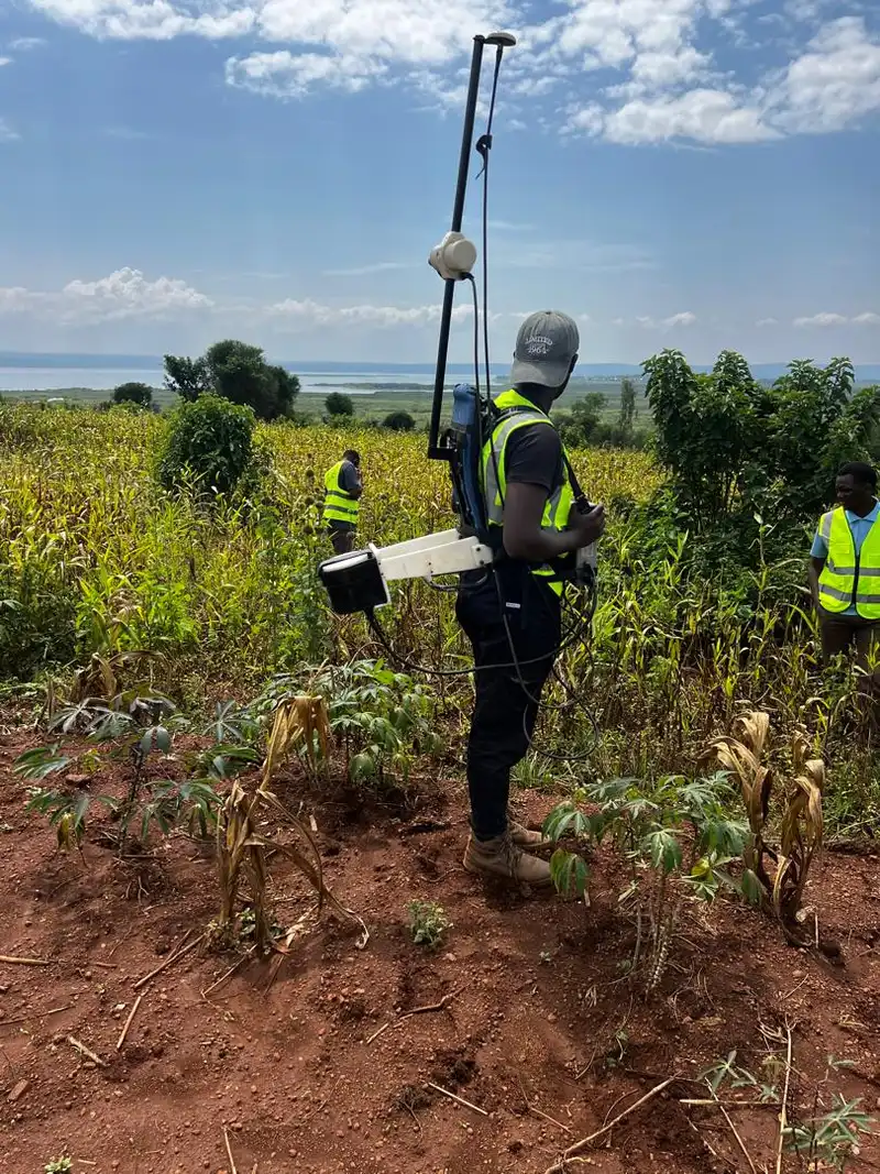
Ground magnetic survey for pegmatite exploration in Rweru, Rwanda

Integrated Geophysical Survey for Pegmatite Exploration — Rweru Sector

Location: Rweru Sector, Rwanda Year: 2026 Client: Confidential mining client

Georesolve delivered an integrated mineral exploration programme in which ground magnetics was the primary structural mapping tool. The GSM 19 Overhauser walking magnetometer was traversed across the pegmatite swarm, producing a magnetic anomaly map that delineated the subsurface magnetic bodies associated with the mineralised intrusives.

Anomalies identified from the magnetic data guided the placement of deep ERT and Induced Polarisation (IP) profiles, which imaged the pegmatite bodies in detail and defined drill targets for cassiterite, coltan, and cobalt follow-up exploration.


View this and other projects in our portfolio →

Frequently Asked Questions

What is a ground magnetic survey?

A ground magnetic survey is a geophysical method that measures the Earth's magnetic field at ground level using a portable walking magnetometer. The operator carries the sensor along pre-planned traverses, recording magnetic readings at regular intervals. The resulting data is processed into a magnetic anomaly map that reveals subsurface geological structures and mineralised bodies without any drilling or ground disturbance.

What equipment does Georesolve use for ground magnetics?

Georesolve uses the GSM 19 Overhauser walking magnetometer, a high-sensitivity proton-precession instrument with built-in GPS for precise positioning. The Overhauser effect delivers higher sensitivity and lower power consumption than traditional proton magnetometers, with no heading error. The built-in GPS allows automatic station positioning without manual surveying.

How deep can a ground magnetic survey see?

A ground magnetic survey does not have a fixed depth limit, but the method is most sensitive to magnetic sources within the upper few hundred metres of the surface. Deeper sources produce broader, lower-amplitude anomalies. The effective investigation depth depends on the size and magnetisation of the source body, the line spacing used, and the magnetic latitude of the survey area.

When should I choose ground magnetics over drone magnetics?

Choose ground magnetics when you need maximum near-surface resolution along specific traverses, when the survey area is small or densely vegetated, or when you are following up anomalies identified by a regional drone magnetic survey. Drone magnetics is better for rapid coverage of large areas and rough terrain. The two methods are complementary and are often combined in a phased exploration programme.

What line spacing should I use for a magnetic exploration survey in Uganda?

Line spacing depends on the target. For regional reconnaissance, 200 to 500 metre spacing is typical. For prospect-scale delineation, 50 to 100 metre spacing is recommended. For detailed anomaly follow-up, lines may be as close as 25 metres. Georesolve advises on the optimal spacing based on your exploration objectives, target size, and expected anomaly amplitude.

Can a magnetic survey find gold in Uganda?

A magnetic survey does not detect gold directly, but it maps the structures and rock types that host gold mineralisation. In Uganda's greenstone belts and shear-zone-hosted gold systems, magnetics is used to map banded iron formations, shear zones, dyke swarms, and alteration patterns that control gold deposition. It is a standard first step in any gold exploration programme.

Related Services

Ready to Map Your Targets?

Talk to Georesolve Africa about a ground magnetic exploration survey for your project in Uganda, Rwanda, Burundi, or the wider East African region.

Request a Quote

Trusted by Leading Organizations

GeoResolve partners with government agencies, consulting firms, and private sector clients across East Africa