SAR & InSAR Services Uganda

Millimetre-level ground deformation monitoring from satellite radar — no ground equipment required. Landslide assessment, subsidence mapping, and structural interpretation using ESA Sentinel-1 interferometry across Uganda and East Africa.

Request a Quote View Related Projects

What Are SAR and InSAR?

Synthetic Aperture Radar (SAR) is a satellite-based imaging technology that illuminates the Earth's surface with microwave pulses and records the reflected signal. Because radar operates in the microwave band, it penetrates clouds, haze, and darkness — making it uniquely valuable in tropical regions like Uganda where persistent cloud cover limits optical satellite imagery. SAR imagery reveals surface roughness, moisture, and structural features with applications in geological mapping, mineral exploration, and infrastructure monitoring.

Interferometric SAR (InSAR) takes the technique further by comparing two radar images of the same area acquired at different times. The phase difference between the two images measures ground deformation that occurred between acquisition dates, with precision down to a few millimetres. SAR and InSAR services in Uganda enable wide-area deformation monitoring without installing any ground-based equipment — a single satellite pass covers hundreds of square kilometres.

Georesolve Africa provides SAR and InSAR services across Uganda, Rwanda, Burundi, and the wider East African region. Using open-access Sentinel-1 data from the European Space Agency's Copernicus programme, combined with commercial high-resolution SAR where required, we deliver deformation maps, structural interpretations, and monitoring time series that support infrastructure safety, landslide hazard assessment, and mineral exploration projects.

How InSAR Works

  1. Data acquisition. A radar satellite (typically ESA Sentinel-1) acquires images of the project area at regular intervals — every 12 days for Sentinel-1 over East Africa. Each image contains both amplitude (reflectivity) and phase (distance to target) information.
  2. Interferogram generation. Two radar images of the same area, acquired at different dates, are co-registered. The phase difference between them is calculated, producing an interferogram. Each fringe in the interferogram represents a specific amount of ground displacement along the radar line-of-sight.
  3. Phase unwrapping. The interferometric phase is measured modulo 2π (wrapped). Phase unwrapping converts the wrapped phase into absolute displacement values, producing a continuous deformation map.
  4. Atmospheric correction. The atmosphere introduces phase delays that can mimic ground deformation. Atmospheric artefacts are identified and removed using weather models, time-series analysis, or stacking of multiple interferograms.
  5. Time-series analysis. For persistent scatterer InSAR (PS-InSAR), dozens to hundreds of images are processed together to identify stable radar reflectors (buildings, outcrops, infrastructure) and track their displacement over time with millimetre-level precision.
  6. Interpretation & reporting. Deformation maps and time series are interpreted in the context of the project — identifying subsidence zones, landslide activity, excavation impacts, or tectonic movement. Results are delivered as GIS-ready layers with a technical report.

Satellite Data Sources

Georesolve processes radar imagery from a range of satellite constellations, selected based on project requirements for resolution, revisit frequency, and wavelength.

Satellite Specification
Sentinel-1 (ESA Copernicus) C-band SAR, 5×20 m resolution (IW mode), 12-day revisit over East Africa, free and open-access. Primary data source for wide-area InSAR monitoring.
ALOS PALSAR-2 (JAXA) L-band SAR, 3–10 m resolution, 14-day revisit. L-band penetrates vegetation, making it ideal for structural mapping in forested and tropical terrain.
ICEYE / Capella X-band commercial SAR constellations, sub-metre resolution, daily revisit available on request for high-priority monitoring projects.
Processing software ESA SNAP, GMTSAR, and commercial InSAR processing pipelines for interferogram generation, phase unwrapping, and PS-InSAR time-series analysis

Applications

Landslide Hazard Assessment

Wide-area deformation monitoring for landslide-prone regions such as Mount Elgon, Bududa, and the Rwenzori foothills in Uganda.

Infrastructure Subsidence

Millimetre-level settlement monitoring over dams, bridges, buildings, tunnels, and pipeline corridors.

Mining & Excavation

Deformation monitoring around open-pit mines, tailings dams, and underground excavations for safety and compliance.

Structural Mapping

SAR imagery reveals faults, dykes, and lithological contacts in vegetated terrain where optical imagery fails.

Mineral Exploration

Regional target generation using SAR structural interpretation combined with magnetic and geochemical data.

Volcanic Monitoring

Ground deformation tracking in the Virunga volcanic province spanning Rwanda, DRC, and Uganda.

Deliverables

Every SAR/InSAR project is delivered as a complete, ready-to-use data package:

Case Study: SAR Remote Sensing for Alluvial Gold Exploration, Ituri, DRC
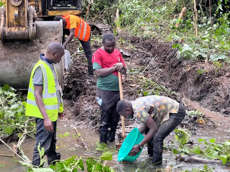
SAR remote sensing for alluvial gold exploration in Ituri, DRC

Alluvial Gold Exploration and Reserves Estimation — Ituri, DRC

Location: Katanga, Ituri, DRC Year: 2026 Client: Confidential mining client

Georesolve delivered a reconnaissance alluvial gold exploration programme in the Ituri region of the Democratic Republic of Congo. SAR remote sensing was used for regional structural interpretation and target delineation, integrated with gold detector data analysis, geological mapping, and geochemical sampling.

The SAR imagery penetrated persistent cloud cover over the tropical terrain, revealing drainage patterns, structural lineaments, and alluvial channel systems that controlled gold deposition. The integrated dataset supported a preliminary reserves estimation framework for the client.


View this and other projects in our portfolio →

Frequently Asked Questions

What is InSAR and how does it work?

InSAR (Interferometric Synthetic Aperture Radar) is a satellite-based technique that measures ground deformation with millimetre-level precision. A radar satellite illuminates the Earth's surface with microwave pulses and records the reflected signal. By comparing two radar images of the same area acquired at different times, the phase difference between them reveals surface displacement that occurred between the two acquisition dates. No ground-based equipment is required.

What can InSAR detect in Uganda?

InSAR can detect millimetre-level ground deformation across wide areas. In Uganda and East Africa, it is used for landslide hazard assessment (e.g. in the Mount Elgon and Bududa region), subsidence monitoring over infrastructure, excavation-induced deformation around mines and tunnels, volcanic unrest in the Virunga region, and structural interpretation for mineral exploration. It maps ground movement over hundreds of square kilometres in a single analysis.

What satellite data does Georesolve use for SAR and InSAR?

Georesolve primarily uses the European Space Agency's Copernicus Sentinel-1 C-band SAR constellation, which provides free, open-access imagery with a 12-day revisit cycle over East Africa. L-band data from JAXA's ALOS PALSAR-2 is used where vegetation penetration is needed. Commercial high-resolution SAR (e.g. ICEYE, Capella) is available on request for projects requiring higher spatial resolution or faster revisit times.

How is InSAR different from ground-based monitoring?

InSAR measures deformation from space over large areas (hundreds of square kilometres) without installing any equipment on the ground. It provides spatially continuous coverage rather than point measurements. Ground-based methods (levelling, GNSS, tiltmeters) deliver higher temporal resolution at specific points. The two approaches are complementary: InSAR for area-wide identification of deformation zones, ground-based methods for continuous monitoring of identified hotspots.

Can SAR be used for mineral exploration in East Africa?

Yes. SAR imagery is a powerful tool for regional structural mapping in tropical and vegetated terrain where optical satellite imagery is limited by cloud cover. SAR highlights linear features, drainage patterns, and lithological contrasts that are difficult to see in the field. Georesolve used SAR remote sensing for regional target delineation in the Ituri alluvial gold exploration programme in the DRC, combining it with geological mapping and geochemical sampling.

How much does an InSAR survey cost in Uganda?

Because Sentinel-1 radar data is free and open-access, InSAR is one of the most cost-effective ground deformation monitoring methods available. The main cost is the processing and interpretation expertise. Pricing depends on the area of interest, the number of acquisition dates analysed, and the level of interpretation required. Contact Georesolve Africa for a tailored quote based on your project area and objectives.

Related Services

Need to Monitor Ground Movement?

Talk to Georesolve Africa about SAR and InSAR services for your landslide, infrastructure, mining, or exploration project in Uganda and East Africa.

Request a Quote

Trusted by Leading Organizations

GeoResolve partners with government agencies, consulting firms, and private sector clients across East Africa